Route n°3 - Le Val d'Aube
Add to my favorites

Outdoor trails under the responsibility of the participant: find out about the conditions and equip yourself accordingly.
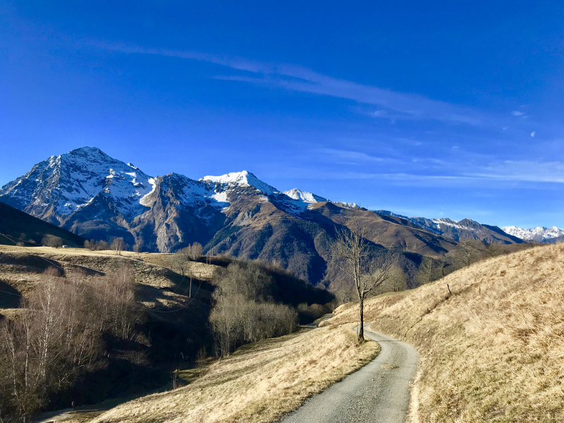
A superb loop combining all the features of the trail. Rolling parts, techniques, steep climbs, balcony paths, etc. After discovering the mysterious Val d'Aube you will return towards Loudenvielle by a magnificent balcony path offering views of the whole valley. A last climb towards Peyresourde Balestas then you will dive towards your starting point by passing by germ, sublime small village of the valley.
The characteristics of the route.

Loudenvielle (65)
- Distance 15.1 km
- Elevation gain 740 m
- Elevation lost 740 m
- Min. elevation 958 m
- Max. elevation. 1522 m
- Duration (depending on pace) 1h30 à 3h
- Suivre le balisage Trail-running n°3 blue

The latest reviews & times

nicofromternant
The 2026/08/20
En savoir plus
Louloutri12
finished in 02:00:00
The 2026/08/12
En savoir plus
Louloutri12
finished in 02:00:00
The 2026/08/12
En savoir plus
Louloutri12
finished in 02:00:00
The 2026/08/12
En savoir plus
PedroElDiablo
finished in 02:15:00
The 2025/10/24
En savoir plus
See all reviews & times
2026/08/20 nicofromternant
Marquage à revoir. Parfois effacé (départ), ou approximatif (après point de vue Spiou, le tourne à droite vers le fond de vallée : pas vu).
2024/08/20 02:30:00
paulinep65
paulinep65
Très beau parcours, très agréable !! Reprise de la montagne après blessure pour moi. Pas de difficulté à suivre avec le balisage. Je recommande.
2023/05/04 Galie
Joli parcours, trace GPX non indispensable mais rassurante surtout dans les prairies. Au départ suivre la route qui passe devant la maison médicale (comme parcours 1) le balisage est visible après. Après la traversée de la rivière un peu avant d'arriver au 1' pic, suivre le balisage GR (rouge/blanc) quand on ne voit pas les balises Trail 3.
2022/04/26 02:00:00
Corentinalx
Corentinalx
Superbe parcours
2021/07/23 sebanger
Superbe parcours. Télécharger gpx car fléchage manquant après le Belvédère des spios.
2020/07/23 02:16:06
Azkaine24
Azkaine24
2020/06/14 02:45:00
Adelyne09
Adelyne09
Une super boucle, qui alterne des montées raides mais courtes et des monotraces très roulantes. Des paysages variés à couper le souffle.
La descente depuis la station est raide et un peu technique mais c'est un pur bonheur, ça passe très bien Boucle faite en alternant course et marche. Merci l'équipe pour cette super trace !
2026/08/20 nicofromternant
Marquage à revoir. Parfois effacé (départ), ou approximatif (après point de vue Spiou, le tourne à droite vers le fond de vallée : pas vu).
2026/08/12 02:00:00
Louloutri12
Louloutri12
super sortie ,extrêmement jolie! un peut compliqué de trouvé certains panneaux plutôt accessible pour les jeunes sportifs
2026/08/12 02:00:00
Louloutri12
Louloutri12
super sortie ,extrêmement jolie! un peut compliqué de trouvé certains panneaux plutôt accessible pour les jeunes sportifs
2026/08/12 02:00:00
Louloutri12
Louloutri12
super sortie ,extrêmement jolie! un peut compliqué de trouvé certains panneaux plutôt accessible pour les jeunes sportifs
2025/10/24 02:15:00
PedroElDiablo
PedroElDiablo
trail très sympa à faire en automne, personne sur le chemin. je trouve ça bien pratique d’avoir le tracé GPX sur la montre, sans ça je me serais perdu !
2024/08/20 02:30:00
paulinep65
paulinep65
Très beau parcours, très agréable !! Reprise de la montagne après blessure pour moi. Pas de difficulté à suivre avec le balisage. Je recommande.
2023/05/04 Galie
Joli parcours, trace GPX non indispensable mais rassurante surtout dans les prairies. Au départ suivre la route qui passe devant la maison médicale (comme parcours 1) le balisage est visible après. Après la traversée de la rivière un peu avant d'arriver au 1' pic, suivre le balisage GR (rouge/blanc) quand on ne voit pas les balises Trail 3.
2022/04/26 02:00:00
Corentinalx
Corentinalx
Superbe parcours
2021/07/23 sebanger
Superbe parcours. Télécharger gpx car fléchage manquant après le Belvédère des spios.
2020/07/23 02:16:06
Azkaine24
Azkaine24
2020/06/14 02:45:00
Adelyne09
Adelyne09
Une super boucle, qui alterne des montées raides mais courtes et des monotraces très roulantes. Des paysages variés à couper le souffle.
La descente depuis la station est raide et un peu technique mais c'est un pur bonheur, ça passe très bien Boucle faite en alternant course et marche. Merci l'équipe pour cette super trace !
Services nearby

Wellness Sport Camping Loudenvielle
Loudenvielle

INTERSPORT Loudenvielle
Loudenvielle

L'Ardoise
Loudenvielle
L'Escapade
Loudenvielle

Louron Valley Visitor Center
Loudenvielle



Follow us on
the digital trails
the digital trails



Info & contacts
Intercommunal Association of the Louron Valley
contact@louronbikeandtrail.fr
Tel. +33 (0)5 62 99 95 35
 Louron Bike & Trail - Parcours - Route n°3 - Le Val d'Aube
Hello, world! This is a toast message.
Louron Bike & Trail - Parcours - Route n°3 - Le Val d'Aube
Hello, world! This is a toast message.
Louron Bike & Trail - Parcours - Route n°3 - Le Val d'Aube
Hello, world! This is a toast message.




OK
Annuler